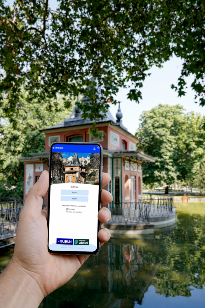
The Deputy Directorate General for Parks and Nurseries has launched two audio guides highlighting the most important features of the Buen Retiro and Madrid Río gardens. Available in Spanish and English, as well as sign language, they can be accessed via QR codes and the city’s website.
In parallel, the Deputy Directorate General for Sustainability has launched an interactive map of 20 parks through the Madrid Móvil app. This map includes geolocated information and audio descriptions of the parks’ flora, fauna, infrastructure, and monuments.
Both initiatives aim to strengthen the role of the city’s green spaces, facilitate knowledge of the urban natural and cultural heritage, and enhance the visitor experience.
The Madrid City Council, through its Department of Urban Planning, Environment, and Mobility, headed by Borja Carabante, has launched two ambitious projects for the city’s parks and green spaces: audio guides and digital content, which will be available to the public next spring. Developed by the General Directorate of Parks and Nurseries and the General Directorate of Sustainability, this initiative, which combines technological innovation, environmental education, and the dissemination of natural and cultural heritage, has the common goal of improving the experience of using, visiting, and understanding municipal green spaces.
These two initiatives form a comprehensive and complementary project that promotes a new way of engaging with Madrid’s parks through digital tools, audio content, and accessible educational resources. Furthermore, they reinforce the role of parks as spaces for leisure, learning, culture, and sustainability, and contribute to improving the relationship between citizens and their urban natural environment.
Both tools are designed to grow, both in the number of parks included and in the functionalities offered, establishing themselves as key instruments for environmental education and the dissemination of Madrid’s green heritage.
Parks and Nurseries Audio Guides
The General Directorate of Parks and Nurseries has developed specific audio guides for two of the city’s iconic green spaces: the Buen Retiro Gardens and Madrid Río. These guides are now available on the municipal website via QR codes (Madrid Río and Buen Retiro Gardens) and direct links, facilitating their use during visits without the need for complex downloads. Designed with universal accessibility in mind, the audio guides include narration in Spanish, English, and sign language, allowing them to reach a wider range of users.
In the case of Retiro Park, the audio tour is structured around 38 key points, offering a comprehensive overview of the park from historical, botanical, cultural, and landscape perspectives. Its highlights encompass the park’s origins, its main promenades, fountains, and historic gardens, as well as unique spaces such as the large pond and the monument to Alfonso XII, the parterre and its emblematic Montezuma cypress, the botanical trails, the Crystal Palace and the Velázquez Palace, the rose garden, the municipal nurseries, the Cecilio Rodríguez Gardens, the Artificial Mountain, and the Book Fair, among many other points of interest.
The Madrid Río audio guide is structured around 22 key points, allowing visitors to understand the historical and urban development of the Manzanares River area, as well as discover historic and contemporary bridges, gardens, sports and cultural facilities, environmental interpretation centers, and leisure areas. The tour includes references to the history of the Madrid Río project, the King’s Bridge, the Segovia Bridge, the Pine Grove, the Arganzuela Park, the greenhouse, the urban “beach,” the outdoor fitness circuits, and cultural spaces such as Matadero Madrid.
Environmental Education and a Digital Tool for Parks
In addition, the General Directorate of Sustainability has created an educational mobile application, designed as a comprehensive guide to Madrid’s parks. Integrated into the Madrid Móvil app as an additional service, it is already operational, constituting a new resource for environmental education and dissemination of the city’s green heritage.
In this first phase, the Madrid Parks app has incorporated an interactive map of 20 spaces in the city with geolocated information and audio descriptions of their flora, fauna, infrastructure, and monuments. It also covers their history, opening hours, services, and other resources of interest to visitors. It is an open platform, designed to progressively incorporate new green spaces, more content, and future functionalities.
Among the historical parks included are spaces such as El Capricho, the Buen Retiro Gardens, Casa de Campo, Parque del Oeste, Dehesa de la Villa, Quinta de los Molinos, Quinta de Torre Arias, Juan Pablo II, and Quinta de la Fuente del Berro. The category of large urban parks includes, among others, Juan Carlos I Park, Valdebebas-Felipe VI Park, Tierno Galván Park, Pradolongo Park, and the Manzanares Linear Park. These are joined by local and neighborhood parks such as Payaso Fofó Park, Azorín Park, Cerro del Tío Pío Park, Palomeras Park, Entrevías Park, and Soto de Entrevías Park, with the intention of expanding the catalog to other green spaces in future phases of the project.
The home screen of the new Madrid Móvil parks service offers an interactive map of the city, available in both standard and satellite views, where the selected parks are geolocated and displayed homogeneous distribution across the urban area. Users can navigate the content in two languages, Spanish and English, and access the complete list of parks via a visual carousel.
The initial selection reflects an integrated vision of Madrid’s green space system, combining historical parks, large urban parks, and neighborhood parks, with the intention of showcasing the diversity and richness of the city’s green heritage and making it accessible to a wide range of audiences.
When a park is selected, a detailed information sheet opens, including a historical summary with the most relevant data, a carousel of images of landmarks, monuments, fauna, flora, and facilities, as well as practical information on location, address, opening hours by season, and available services. The application also allows users to consult lists of points of interest, apply filters by category, activate text narration, and mark parks as favorites to create personalized routes.